
Converting agricultural land to residential use in Trinidad and Tobago
To seek permission to use agricultural land for housing in Trinidad and Tobago, submit a planning application to the Town and Country Planning Division (TCPD) through DevelopTT that expressly identifies the existing agricultural use and the proposed residential use. Include the land, buildings and subdivision you want approved. TCPD assesses whether that proposal can be permitted on that site. Where an agricultural lease restricts the use, the landowner’s approval and the necessary lease arrangements must also be obtained. Residential use depends on the written decisions and their conditions.
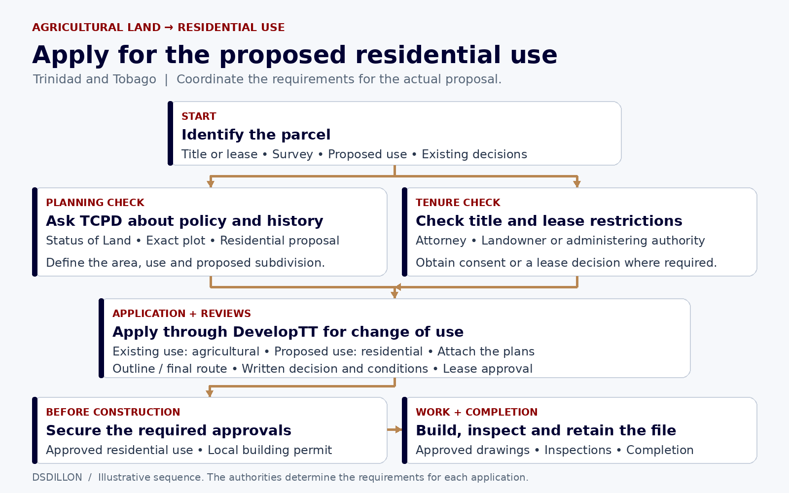
What are you applying to change?
Agricultural land can mean land used for farming, land subject to agricultural planning policy, or land held under an agricultural lease. Those descriptions concern different legal and administrative matters. Establish which ones apply to your parcel before choosing the application and commissioning plans.
Section 8 of the Town and Country Planning Act, Chapter 35:01, includes a material change in the use of land within the meaning of development. Sections 9 and 11 provide for planning permission and the determination of applications. The Minister responsible for planning has the statutory decision-making power; TCPD administers the planning process. A grant may contain conditions, and an application may be refused.
For an owner seeking residential use of a particular parcel, the application must describe that proposed development. A formal amendment of a development plan is a separate process under sections 6 and 7 of the Act. An individual planning permission does not, by itself, rewrite the development plan for the surrounding area.
| Question | Decision or record needed |
|---|---|
| Can this specified land be used for the proposed residential development? | Planning permission covering the proposed use and the relevant land, subject to its conditions. |
| Can a tenant use agricultural leasehold land for housing? | The lessor’s consent and any required change to the lease or replacement land instrument, as well as planning permission. |
| Can the proposed house be constructed? | Approval of the building proposal and the relevant local authority’s building permit. |
| Has the mapped planning policy changed? | Confirmation from TCPD of the applicable policy and any formally adopted amendment. |
| Does a Status of Land letter approve conversion? | It reports the planning position. A separate application and favourable decision are required where the proposed development has no applicable permission. |
Step 1. Establish the ownership, boundaries and existing restrictions
Assemble the deed or Certificate of Title, the survey plan, the lease if there is one, and all previous planning decisions and approved plans. A cadastral plan identifies land parcels and their boundaries. Check that the parcel number, area, location and boundaries agree across the documents.
Have an attorney examine the title, the people entitled to deal with the property, restrictive covenants, lease conditions and legal access. Where the owner has died, the land is jointly owned or a transfer is incomplete, establish who can lawfully authorise the application. Planning permission does not confer ownership or remove private rights over the land.
Engage a land surveyor where the boundaries, existing survey or proposed excision need professional work. If you propose to develop a portion of a larger holding, identify both the whole holding, called the parent parcel, and the portion affected by the application. A sale agreement describing a small plot does not establish that its subdivision has planning permission.
Keep copies of the documents in a project file. Record the existing TCPD application references and any State land file or lease reference. These identify the records the authorities need to examine.
Step 2. Obtain the planning status of the exact parcel
Use the Status of Land service on DevelopTT to obtain TCPD correspondence about the site. Supply the ownership and survey information required by the service and the previous application references you hold. Read the current online checklist before submitting.
The enquiry should establish the mapped land-use policy, the planning status of the plot and the relevant approval history. Obtain the actual approval letters and endorsed plans for any residential permission said to exist. Check whether they cover the proposed site, development and use.
Keep this distinction clear when buying land: a letter describing agricultural policy, a tax or stamp-duty classification, a registered deed and an approved residential development are different records. Ask the seller to identify the particular permission on which any claim of residential approval relies.
- Match the parcel on the letter to the survey plan and title.
- Check whether an earlier decision covers the whole parcel or only part.
- Identify conditions, reserved details and outstanding approvals.
- Take unresolved planning-history questions to the TCPD office responsible for the location.
Step 3. Define the residential proposal and discuss the policy issue
Decide exactly what you want to establish: one dwelling on the existing parcel, a defined residential portion with agricultural land remaining, several dwellings, or a residential subdivision. State the number of dwellings, the area to change use, the access and what will happen to the remainder. These are materially different proposals.
Use TCPD’s regional pre-application advice service to discuss the proposal against the applicable planning policy. Bring the Status of Land response, title, survey, previous decisions and a sketch of the intended development. Ask whether the proposed residential use is acceptable in principle, whether an outline application is appropriate, and which site or policy issues the formal application must address.
Agricultural suitability is relevant to the assessment. TCPD’s published developer guidance describes consultation on the agricultural capability of undeveloped or agricultural land, including land no longer actively farmed. Abandonment of cultivation does not establish an entitlement to residential development. The 1988 guide uses historical ministry names; use TCPD’s current referral instructions for the application.
A preliminary discussion helps define the submission. Obtain a written planning decision before treating the proposal as approved. Where TCPD identifies a policy objection, ask for the policy and reasons to be identified so your planning adviser can address the actual issue.
| Issue to investigate | Why it matters to the proposal |
|---|---|
| Agricultural policy and capability | The assessment considers the loss of agricultural land and the policy applying to the area. |
| Surrounding development | Existing uses and previous decisions inform compatibility; another property’s approval does not approve your parcel. |
| Access and roads | The layout must address access, road connections and the movement generated by the development. |
| Drainage, flood conditions and slopes | The design and supporting work must address the site’s physical constraints. |
| Water and wastewater | The proposal must provide suitable servicing arrangements. |
| Parent parcel and remainder | An excision or subdivision must explain the resulting parcels and their access. |
Step 4. Address an agricultural lease before relying on residential use
If the land is leasehold, read the permitted-use, building, subdivision and consent clauses with your attorney. Tell the lessor exactly what is proposed. Obtain the owner’s authorisation required for the planning application and establish the landowner’s procedure for considering residential use.
For State land, contact the Land Management Division, headed by the Commissioner of State Lands, through the Ministry of Land and Legal Affairs. Give the State land file reference and ask which office is administering the tenancy or lease. The Division’s responsibilities include State leases and renewals, tenancies, consents and building plans on State land.
Prepare the lease or tenancy documents, survey, proposed residential area, proposed use of the remainder and available TCPD correspondence for that enquiry. Request written instructions on the submission required for your file, the approvals needed and the land instrument that would authorise the proposed use. These documents are a practical enquiry file; the responsible office must specify its application requirements.
If a change is approved, comply with the stated survey, valuation, payment and legal-document requirements applicable to that decision. Have the attorney check when the consent or lease change becomes effective. A planning approval does not itself amend an agricultural lease. A favourable lease decision also leaves the planning and building approvals to be obtained.
A Ministry statement dated 17 February 2021 describes particular cases involving proposed residential leases, residential valuation and Cabinet approval, with separate treatment of agricultural land remaining. It does not establish a general entitlement to convert every State agricultural lease or a universal conversion price. Building additional houses in breach of an agricultural lease can put the tenancy or renewal at risk.
Step 5. Prepare the application plans and supporting documents
Use the checklist for the application being made. An outline submission establishes the proposal and site with less design detail. A final application must contain the details necessary to determine the development actually proposed. Where the proposal includes new buildings, their plans are required; where it includes subdivision or engineering works, the relevant layout and engineering details must be included.
For a change in land use, the plans must identify the land affected and the proposed use of each relevant plot. Where only part of a larger parcel is affected, show its position within that larger parcel. This is essential where a residential portion will coexist with an agricultural remainder.
The ownership document should be complete and legible. A survey plan should relate to the actual site. Have the appropriate professionals prepare the survey, building design and engineering material within their respective competence. Use the official checklist to agree their deliverables before commissioning the work.
| Submission item | What to prepare |
|---|---|
| Ownership and applicant authority | Deed, Certificate of Title or relevant tenancy evidence; owner details and authority where an agent applies. |
| Survey and location | Parcel identification, boundaries, area and location relative to adjoining land and roads. |
| Description of development | Existing use, requested residential use, affected area, number of dwellings and any subdivision or works. |
| Site or layout plan | The proposed arrangement, access, buildings, setbacks, servicing and the relationship to the parent parcel. |
| Building drawings, where relevant | Floor plans, elevations, sections and roof information appropriate to the proposal. |
| Site and engineering information, where relevant | Topography, drainage, roads, grading and other details required for the particular development. |
Step 6. Start the Planning Permission application in DevelopTT
Open DevelopTT and use its registration guidance to obtain the account needed to submit. Choose the Planning Permission service. Complete the preliminary screening accurately. The applicant guide describes screening routes leading to an outline and planning-permission application, or a planning-permission application, according to the answers supplied.
An outline application can establish whether the proposal is acceptable in principle before all detailed designs are prepared. If outline permission is granted, read the reserved matters and conditions. Submit the required detailed application and obtain the remaining approval before proceeding with development. Outline permission alone does not authorise construction.
Use the online workflow and current checklist displayed for the application. The linked paper planning form is a reference for the information sought; historical instructions about paper copies should not be substituted for the current electronic submission procedure.
Step 7. Expressly apply for the agricultural-to-residential change
Enter the applicant and owner information, the site location and area, and the proposal in the application. The DevelopTT guide identifies fields for the development category and description, together with existing and proposed land or building purposes. Describe the agricultural use or existing condition accurately and identify the requested residential use.
Choose the development category appropriate to the full proposal. A proposal involving change of use, new buildings and subdivision needs those elements identified and assessed. Obtain assistance from TCPD if the available category or screening route does not reflect the proposal. Do not omit subdivision or works to fit a simpler application.
An illustrative description is: “Proposed change of use of [area] at [parcel and location] from agricultural use to residential use for [number] dwelling(s), with [describe access and proposed works]. The application affects [the entire parcel / the portion shown on the attached plan]. The remaining [area] is proposed to remain in agricultural use.” Adapt every bracketed item to the facts. Where lots are to be created, identify the proposed subdivision.
Upload the supporting documents under the relevant headings. Check that the description, affected area and dwelling or lot numbers agree with the drawings. Review the application summary and declarations before submission. Save the submitted version, acknowledgement and application reference for subsequent correspondence.
Step 8. Answer TCPD queries and complete the relevant agency reviews
TCPD considers the proposal against land-use policy, planning standards, site conditions and the relevant technical advice. The application may require further information or amended plans. Use the reference number when responding, and answer each item in the query so the authority can see what changed.
Where additional time is needed to respond, use the published DevelopTT query-extension procedure and check the response. Keep the application status, messages and response dates under review. An unanswered request for information leaves the authority without material needed to complete the assessment.
Agency involvement depends on the development. Agricultural advice concerns the land’s agricultural capability and policy. Road, drainage, water, wastewater and environmental matters may require assessment or approval by the relevant bodies. Follow the referral instructions and the conditions actually imposed on your application.
A Certificate of Environmental Clearance (CEC) is required where the proposal falls within a designated activity under the environmental legislation. It is not a universal certificate for every change-of-use proposal. Check the EMA’s designated activities and applicable thresholds, including the associated infrastructure, and obtain the required clearance before carrying out the activity. An environmental impact assessment may be required within the CEC process; it is not required for every application.
Step 9. Read the decision and establish exactly what it approves
Obtain the written decision and its approved plans. A favourable decision must be read together with its description, boundaries, conditions and reserved matters. Check that residential use is authorised for the land you intend to use and that the number and type of dwellings or lots correspond with your proposal.
If the decision concerns outline permission, complete the required detailed stage. If it is a final permission subject to conditions, identify which conditions must be satisfied before work, during development or before occupation or completion. Obtain the further approvals and submit the details specified in the decision.
Approval for a dwelling on a defined portion does not authorise houses across the rest of a farm. Permission for a house does not by itself approve a subdivision for residential sales. A homestead proposal must be assessed under the applicable agricultural layout guidance and the terms of any lease.
Keep the decision and endorsed plans with the title and survey documents. When explaining the position to a buyer, lender or contractor, identify the actual approved development and outstanding conditions. Avoid describing land as unconditionally residential where the decision grants a narrower or conditional permission.
- Confirm the application reference, parcel and applicant details.
- Check the authorised use, affected area and approved plan versions.
- Record every condition and any time limit stated in the decision.
- Establish which matters require a further written approval.
- Complete the separate lease arrangements where agricultural lease restrictions apply.
If permission is refused or agricultural policy prevents the proposal
Read the refusal notice before spending money on another submission. Separate issues that can be addressed through design or evidence from an objection to residential use itself. For example, revising access or drainage does not necessarily answer a refusal based on retention of land for agriculture.
TCPD describes two routes after refusal: submit revised plans addressing the reasons, or request review by the Minister responsible for planning through the Advisory Town Planning Panel (ATPP). Its published procedure states that a favourable Ministerial review is followed by resubmission to TCPD with the Ministerial letter. Obtain the current submission instructions from the responsible regional office and have your adviser address each refusal reason.
Section 13 of the Act provides a statutory appeal in the particular situation of a decision by a local planning authority exercising delegated powers. That provision should not be treated as a universal appeal route or deadline for every TCPD refusal. Have the actual notice and decision-maker checked promptly to establish the applicable procedure and time limits.
If the issue requires changing the applicable development plan, sections 6 and 7 provide for an amendment process involving the Minister and Parliament, with public notice, access to the draft and an opportunity for representations. It is a separate public planning process. Discuss a proposed policy review with TCPD; submitting an individual residential application does not compel a change to agricultural policy.
Until the necessary favourable decisions are obtained, the proposed residential development remains unapproved. Paying a professional, obtaining a survey or purchasing the land does not ensure that the planning objection will be removed.
Step 10. Complete subdivision and land arrangements where required
If the proposal creates separate residential lots, obtain the relevant subdivision approval and satisfy its layout and infrastructure conditions. TCPD’s residential subdivision guideline applies to areas zoned for residential development. A housing layout on land subject to agricultural policy must address that policy issue in the planning process.
The approved layout and the survey used to create or convey lots must correspond. Follow the required final survey or ratification procedure with your land surveyor. Material changes to the approved layout require the appropriate planning application. Have the attorney ensure that any conveyance or new lease describes the approved parcel and deals with access and other necessary rights.
For State land, complete the land administration and legal-document steps specified in the approval. Confirm that the residential permission and the lease or other instrument authorise the same land and intended use. A discrepancy in the area or boundaries should be resolved before construction or a transaction proceeds.
Step 11. Obtain the building permit and approvals needed for the work
For a proposal involving construction, continue to the relevant local authority’s building approval process. In Trinidad this is the municipal corporation responsible for the site. Planning permission and a building permit serve different purposes; the building plans must satisfy the relevant health, safety and construction requirements.
The DevelopTT planning workflow provides for onward processing of an approved application and relevant agency involvement. Follow the application’s instructions for municipal, WASA and other approvals. The Ministry’s WASA guidance describes applications through DevelopTT for applicable construction-related water and sewage services.
Obtain the building permit before starting construction and comply with all applicable pre-commencement conditions. Confirm the permissions needed for associated road, drainage, excavation and other works before beginning them. The planning approval of a future house is not permission to carry out every possible engineering operation on the land.
In Tobago, submit through DevelopTT for the Tobago planning region and deal with TCPD’s Tobago office. Coordinate local building and infrastructure requirements with the appropriate Tobago House of Assembly offices. Use the Tobago process for the site rather than assuming that a Trinidad municipal corporation administers it.
Step 12. Follow the approved plans through inspection and completion
Build in accordance with the approved drawings and conditions. Establish the inspection requirements with the local authority and arrange inspections at the required stages. Refer proposed changes to the relevant authority before implementing them where revised permission or building approval is needed.
Complete the required works and conditions and obtain the relevant completion documentation after the authority’s inspection process. Keep the planning permission, building permit, agency approvals, completion certificate, final survey and lease or title documents together. This record explains both the land’s authorised use and the approvals for the completed development.
Costs and time: what can be stated accurately
TCPD publishes that no fee is charged for obtaining its planning permission. The Planning Ministry’s 3 September 2026 DevelopTT announcement also describes its services as available at no cost. Professional work, building permits, surveys, engineering investigations, infrastructure and any State land financial terms remain separate matters.
Ask each professional for a written scope and fee identifying the application stages included, drawings to be delivered, query responses, revisions and any additional disbursements. Obtain the local authority’s applicable building fees and the written terms of any land administration decision. A planning application fee cannot be used as an estimate of the total project cost.
The route may involve outline and final stages, revised information, agency reviews, a refusal review, infrastructure approvals and lease documentation. The completion date therefore depends on the actual application and the decisions still outstanding. Obtain stage-specific estimates from the responsible offices and professionals; do not base a purchase or construction commitment on a guaranteed conversion date.
The documents that demonstrate the result
At the end of the process, the file should allow another person to identify the parcel, the authorised residential use and the approvals needed for the actual development. The relevant documents depend on whether the project involved a change of use only, construction, subdivision or leasehold land.
| Document | What to check |
|---|---|
| Planning decision and approved plans | The residential use, affected land and permitted development match your intended use. |
| Conditions and further approvals | Reserved matters and applicable pre-commencement requirements have been addressed. |
| Lease consent or replacement instrument, where required | The landowner has lawfully authorised the proposed use on the same parcel. |
| Approved subdivision and final survey, where required | The lots and access correspond with the planning permission. |
| Building permit and agency clearances, where required | The actual construction and associated works have their necessary approvals. |
| Completion documentation, where required | The relevant authority’s completion process has been concluded. |
Forms, authorities, surveyors and attorneys
Use the DevelopTT service portal for applications and its registration and applicant guides for submission instructions. The application document checklist distinguishes outline, building and subdivision information. Contact the relevant TCPD regional office for the planning position and application queries.
The linked directory contains TCPD offices, land administration and environmental contacts, professional registers, and surveying and legal practices with published contact details. Confirm the individual professional’s current registration and obtain a written engagement describing the work required for your parcel.
- DevelopTT online applications and service checklists
- DevelopTT registration guides and forms
- DevelopTT application document checklists
- DevelopTT applicant user guide
- TCPD final planning permission form: reference copy
- TCPD regional office contact details
- Ministry of Land and Legal Affairs: Land Management Division
- EMA: CEC applications, legislation and fees
- Land Survey Board and registration information
- Law Association member directory
- Board of Architecture: 2026 registered architects
- Board of Engineering of Trinidad and Tobago
Discuss your land project
Tell us the location, the documents you hold and the development you have in mind.
Contact DSDillonThis guide provides general information. Obtain advice on the title, lease, site and approvals for your particular proposal.