
Land Classifications in Trinidad and Tobago
Land in Trinidad and Tobago is described by its planned use, legal ownership, tenure, physical capability and valuation use. Agricultural, residential, commercial and industrial describe uses. Freehold and leasehold describe interests in property. A buyer needs the planning position and the title position for the same parcel before deciding whether it suits a home, farm or business.
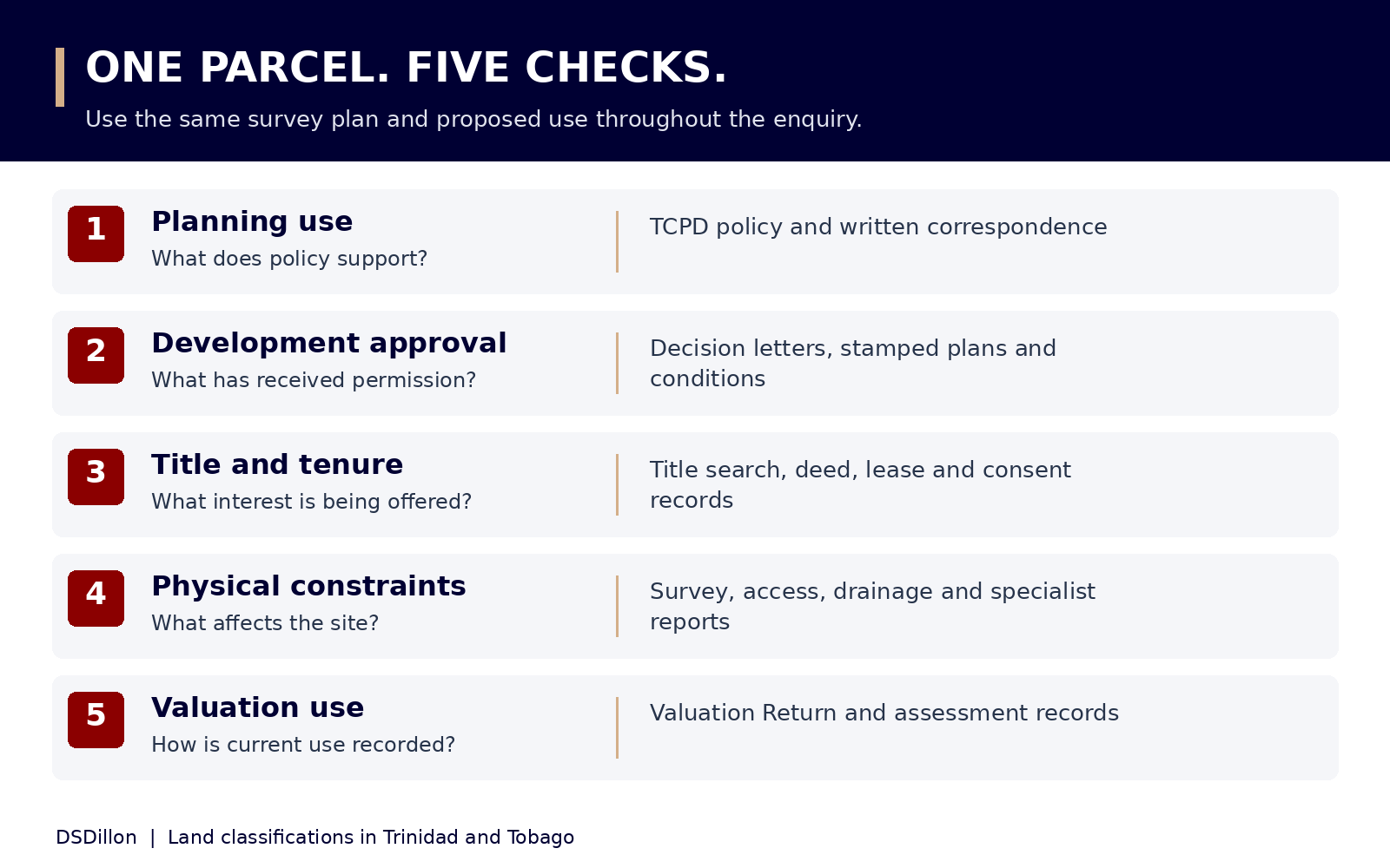
Start with five questions about the same parcel
Ask who owns the land, what interest is being offered, which land use policy applies, what development has received approval, and what physical or environmental limits affect the site. Keep the answers together. A listing often gives only one or two of them.
For example, a parcel offered as freehold agricultural land has both a tenure description and a land use description. A leasehold residential lot also needs its lease terms and planning approvals checked. These descriptions work together.
| Question | Evidence to examine |
|---|---|
| Who owns it and what is being transferred? | Title search, deed or Certificate of Title, lease and transfer documents |
| What uses does planning policy support? | TCPD correspondence, policy map and applicable local plan |
| What has actually been approved? | Decision letters, stamped drawings and conditions |
| What constraints affect the ground? | Survey, access, drainage, soil and environmental information |
| How is its current use recorded for valuation? | Valuation Return, assessment records and Valuation Division correspondence |
Agricultural land and the A1 to A5 categories
Agricultural land supports farming activities. TCPD’s agricultural subdivision guideline groups activities into A1 to A5 and gives the following minimum parcel sizes. These are agricultural subdivision standards. A particular parcel still needs its own planning and tenure checks.
- Read the approved agricultural layout before buying a portion of a larger holding.
- Describe any proposed house, farm building, processing activity or subdivision separately when asking TCPD about the site.
| Code | Activity | Minimum parcel size |
|---|---|---|
| A1 | Extensive livestock farming, including dairy cattle | 8 hectares |
| A2 | Extensive agriculture, including tree crops and sheep or goats | 4 hectares |
| A3 | Mixed agriculture, large farms | 2 hectares |
| A4 | Mixed agriculture, small farms | 1.2 hectares |
| A5 | Intensive agriculture, mixed vegetables | 0.5 hectare |
Homestead land
TCPD’s agricultural subdivision guideline describes a homestead as a minimum 0.4 hectare parcel used primarily for a household’s residence, with land for household agriculture. It discusses possible homesteads within 0.6 kilometres of established villages and referral to the Regional Corporation. These provisions depend on an application and its circumstances.
The Valuation Division’s 2021 Return instructions use homestead for one residence on a parcel of at least half an acre. Always identify the document using the term. A valuation description establishes no entitlement to subdivide or build.
Residential land
Residential use concerns housing. The development proposal should identify the intended housing form: one dwelling, a duplex, townhouses, apartments or a larger residential layout. Ask for the permitted density and the standards affecting the lot before drawing up a scheme.
For a subdivision, TCPD’s residential layout guideline requires the final survey layout to be prepared by a licensed surveyor and ratified where a preliminary layout was approved. A significantly different final layout requires a new application. Buyers should obtain the final documents for the lot they are purchasing.
- Ask how many dwellings are approved on the parcel.
- Check access, drainage, parking, setbacks and any outstanding conditions.
- Match the approved lot number and area to the survey and title documents.
What do R1 to R8 mean?
The updated hierarchy describes residential density as follows. Its implementation text begins with specified Port of Spain areas, excluding Belmont and East Port of Spain from that study area. Confirm the policy and standards applied to your parcel with TCPD.
| Code | Density description |
|---|---|
| R1 | Very low |
| R2 | Low |
| R3 | Low to medium |
| R4 | Medium |
| R5 | Upper medium |
| R6 | High, borough cores or central business districts |
| R7 | High, city suburbs |
| R8 | Very high, city cores |
Commercial land and business premises
Commercial proposals include activities such as shops, offices and services. Give TCPD the actual business activity, floor area, opening hours, customer numbers, deliveries and parking needs. This makes the proposed use clear when checking an existing approval or preparing an application.
A tenant taking over a shop for a restaurant should check the approved use before signing a lease or fitting out the premises. TCPD’s planning and mortgage guidance identifies changes between use classes as matters requiring planning consideration, with exceptions depending on the legislation.
- Request the existing planning permission and approved drawings from the owner.
- Describe cooking, alcohol sales, outdoor activity, storage or machinery where relevant.
- Ask which planning change, building work or operating licence the proposed business requires.
What do C1 to C7 mean?
The same hierarchy grades commercial intensity. The category helps describe the scale of activity. Ask TCPD to confirm its application to the site.
| Code | Commercial intensity |
|---|---|
| C1 | Low neighbourhood intensity |
| C2 | Medium neighbourhood intensity |
| C3 | Medium to high neighbourhood intensity |
| C4 | High, central business district level |
| C5 | High, concentrated comprehensive development |
| C6 | High, including national centre services |
| C7 | Highest intensity |
Industrial land
Industrial activities include manufacturing, processing and related operations. The activity, its scale and its effects on surrounding land matter. A storage warehouse, repair workshop and manufacturing plant present different planning questions.
Before committing to premises, prepare an operations description covering equipment, materials, vehicle movements, loading, noise, emissions and waste. Ask the planner to identify the applicable industrial policy and the approvals needed for the specific operation.
EMA assesses designated activities through the Certificate of Environmental Clearance process. A CEC records environmental acceptability subject to its conditions. Check whether the proposed new or modified activity falls within the Designated Activities Order.
Mixed use land and buildings
Mixed use brings two or more uses together. Examples include a shop with apartments above or residential accommodation associated with tourism. TCPD’s bed and breakfast guideline expressly refers to residential-commercial and resort-residential designations.
List every proposed use and its floor area. Ask how parking, access, servicing and residential amenity will be assessed together. For an existing building, obtain the approved drawings for each floor. A description such as mixed use should be supported by the applicable policy and the permission granted.
Tourism, resort and visitor accommodation
Tourism-related land uses include visitor accommodation and associated facilities. Before buying a house for a guesthouse or bed and breakfast, check the approved use and local planning policy.
TCPD’s guesthouse and bed and breakfast guideline requires an application to change an existing development’s previously approved use to the relevant guesthouse or residential/bed and breakfast use. It also addresses density, access, parking and site standards. Ask TCPD how the proposed accommodation will be treated at the chosen location.
Institutional and community uses
Institutional and community uses serve activities such as education, worship, health care and community facilities. The planning legislation addresses the siting of schools, churches, meeting halls and other facilities within communities.
Describe the facility precisely when checking the land: a place of worship, school, consulting room and residential care facility have different operating needs. Prepare expected attendance, opening hours, transport arrangements and proposed buildings for the planning enquiry.
Recreation, open space and infrastructure reserves
Open space, parks, recreation grounds and land reserved for public infrastructure require their own checks. A vacant strip beside a road or drain deserves investigation before it is included in a purchase or building layout.
Ask the surveyor to identify the parcel boundary and any marked road or drainage reserve. Ask the attorney to examine rights affecting it. Request the applicable plan from the relevant authority and establish whether a reservation or proposed public work affects the site. Keep written answers with the purchase file.
Forestry, conservation and environmentally sensitive areas
Land described as forested, conservation land or environmentally sensitive needs a check of the actual policy, boundary and legal designation. EMA publishes designation notices for areas including Aripo Savannas, Matura National Park and Nariva Swamp.
Start with the relevant notice and map. Ask the responsible authority how the proposal relates to the designated area, its boundaries and restrictions. Describe proposed clearing, filling, road access and buildings together. Avoid treating a cleared patch or an existing track as evidence of permission for further work.
- Locate the parcel against the designation map.
- Identify any forestry, environmental or planning authority whose decision is required.
- Obtain advice before changing vegetation, drainage or ground levels.
Agricultural land capability and soil classes
Agricultural capability describes the land’s suitability and limitations for farming. The national spatial strategy’s background document discusses capability classes I and II and classes III to V in its assessment of agricultural resources. Such references concern soil and agricultural potential.
The Soil and Land Capability Unit provides soil surveys, mapping and capability reports for farmers and agencies, including TCPD. Ask for the report and its classification legend for the actual site. A statement that land has poor agricultural capability still leaves the planning application to be determined.
For a farm purchase, ask which crops and management measures suit the site. For a proposed building project, obtain the appropriate engineering advice on ground conditions as well.
Freehold, leasehold, private land and State land
Freehold describes a property interest without a fixed lease expiry. Leasehold describes rights for a term under a lease. Private and State identify ownership. Agricultural, residential or commercial identify use. Record all applicable descriptions.
The Commissioner of State Lands administers State land interests and processes matters including leases and consents for transfers, assignments and mortgages. A State agricultural lease needs examination of its permitted purpose and conditions. Ask which consents apply to the proposed transaction and development.
Title documents, occupation and Certificates of Comfort
TCPD’s property terminology guideline distinguishes Common Law documents from documents under the registered system. A Certificate of Title, deed, memorandum of transfer or lease should be read for the interest it records.
A Certificate of Comfort provides specified protection from ejectment under the State land regularisation framework. It creates no interest in the land. Ask an attorney to establish the rights being offered and any outstanding regularisation steps before paying for an interest described only as possession, family land or squatter land.
Valuation categories and the property’s recorded use
The Valuation Division records property information for the Valuation Roll. Its published forms distinguish residential, commercial, agricultural, mixed use and special purpose descriptions. Its 2021 instructions describe mixed use as a combination of residential, commercial or agricultural purposes.
The Division explains that a WASA bill does not establish ownership. Title documents and lease documents serve different evidential purposes. A valuation entry should therefore be read alongside the title and planning documents.
If the records use different descriptions, identify their dates and purposes and ask each issuing office to clarify its entry. The Return also identifies special purpose buildings designed for particular uses, including hospitals, hotels and religious buildings.
The statutory Use Classes Order
The Use Classes Order is another classification system. Its nine classes cover shops; offices or banks; specified warehousing; worship; specified childcare or consulting premises; galleries and similar facilities; meeting or concert halls; theatres or cinemas; and gyms, indoor games or community centres.
The Order addresses changes within a class and contains definitions and exclusions. Request advice on the precise proposed activity, including the legal definition of shop.
Checking land in Tobago
Use the TCPD Tobago office for the planning position. For State land under THA’s responsibility, contact the THA Land Management Department about tenure and land administration. THA describes its functions as including surveys, cadastral information and State land applications.
Give each office the same survey plan, location and proposal. Ask which documents and decisions are needed from TCPD, THA and other agencies for the particular parcel. Where an online map or old letter leaves the boundary unclear, request a site-specific explanation.
What to obtain before paying a deposit
Build a parcel file before agreeing an unconditional purchase. Ask your attorney to address any outstanding planning, title, access or lease questions in the agreement. The necessary conditions depend on the property and the intended use.
- The seller’s title documents and authority to sell.
- A survey plan identifying the exact parcel and access.
- A current written explanation of the planning policy, including a Status of Land application where appropriate.
- The relevant subdivision and development approvals, stamped plans and conditions.
- The lease and required consents for any leasehold interest.
- The site investigations needed for drainage, ground conditions and environmental constraints.
- A written answer about the intended use: a home, rental units, farm, shop, warehouse or other project.
Forms, organisations and professional help
Choose the organisation according to the question. A planner examines the proposal against policy. An attorney investigates title and transaction terms. A licensed land surveyor identifies the parcel and prepares the required survey work. An engineer assesses the relevant ground, drainage or structural matters.
The linked application portals provide the current submission routes and document requirements. The professional directory includes surveyors and attorneys. Confirm the individual’s registration, scope of work and written fee before appointment.
- DevelopTT e-Services and application requirements
- DevelopTT Public Application Register and policy map
- TCPD documents and regional office contacts
- Land Management Division and Commissioner of State Lands
- THA Land Management Department
- Soil and Land Capability Unit
- EMA environmental clearance, forms and application portal
- Valuation Division frequently asked questions
- Surveyors, attorneys and land approval resources
- Apply for a Status of Land letter
- Agricultural to residential land: the approval process
Discuss your land project
Tell us the location, the documents you hold and the development you have in mind.
Contact DSDillonThis guide provides general information. Obtain advice on the title, lease, site and approvals for your particular proposal.