
Land Surveying in Trinidad and Tobago: A Complete Guide
To arrange a boundary survey in Trinidad and Tobago, engage a registered and licensed Trinidad and Tobago Land Surveyor (TTLS). Give the surveyor the title documents and existing plans, agree the work and charges, and establish the survey’s purpose. The surveyor investigates the records, arranges the required notices, carries out the fieldwork and prepares the appropriate plan and report. Registration and any required approval follow the applicable procedure.
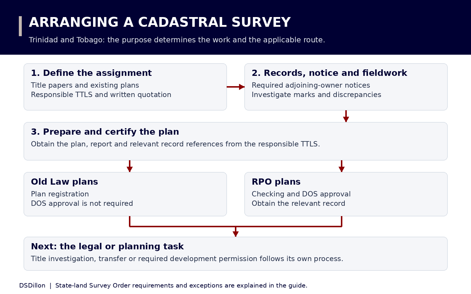
Step 1: explain why you need the survey
Start with the decision you need to make. Are you buying a parcel, locating an existing boundary, dividing land, preparing a building design or checking a suspected encroachment? These tasks can require different survey work and different documents.
Give the surveyor any written requirements from your attorney, lender, architect, engineer or approving authority. Ask which deliverables will satisfy that purpose. A cadastral survey deals with parcel boundaries; a designer may also need topographical information such as levels, drains and existing structures.
What are the different types of land surveys?
UWI distinguishes several fields of surveying. A project can require more than one. State the intended use when requesting a quotation so that the work includes the information your professional team needs.
| Type | What it deals with | Example of a reader’s need |
|---|---|---|
| Cadastral or boundary survey | Parcel boundaries and the spatial extent of land interests. | Identify the parcel being purchased or investigate boundary marks. |
| Topographical survey | Natural and built features, with heights or levels where included in the scope. | Supply site information for a building or drainage design. |
| Engineering survey | Measurements for the design, construction and monitoring of works. | Set out construction positions or record completed works. |
| Geodetic survey | The reference framework used to position other surveys. | Connect measurements to an established control system. |
| Hydrographic survey | Water features, coastal areas, offshore positioning and tides. | Provide measurements for a marine project. |
Step 2: check the surveyor’s registration and category
For cadastral work, check the individual responsible for the survey in the TTLS category. The Land Surveyors Act distinguishes a Trinidad and Tobago Land Surveyor from a Land Surveyor registered in another category and from a Land Surveying Graduate. A company name, university qualification or membership description alone does not answer the licensing question.
Open the official register, match the person’s full name and TTLS number, and check supplemental notices. Ask for evidence of current registration and confirm uncertainties with the Land Survey Board. For a firm, identify the individual who will take professional responsibility for your cadastral survey and certify the plan.
The 2026 Gazette includes separate lists for TTLS practitioners, other categories and firms. Its main annual list records registration as at 1 February 2026, with supplemental entries. Verify current status when instructing a professional.
Step 3: assemble the property file
Supply complete, legible copies of the documents you have. Explain missing records rather than filling gaps from memory. The surveyor can identify further records needed for the work; your attorney should address questions about title or authority to act.
For a proposed purchase, arrange access through the seller or authorised representative. Do not assume that an advertisement, a tax assessment or a pin dropped on a map identifies the legal parcel.
- The deed and attached schedules and plans, or the Certificate of Title and relevant instruments under the Real Property Act.
- Earlier survey plans, survey plan references, cadastral sheet references and any previous boundary reports.
- The location, access directions and contact details for the owner or person authorising the work.
- Existing subdivision or planning approvals, approved layouts, State lease papers and any relevant Survey Order.
- Details of missing marks, fences, walls, occupation, access disputes or differences between documents.
- The receiving authority’s or professional’s requirements for the finished plan and report.
Step 4: agree a written scope, quotation and delivery stages
Ask for a written description of the parcel and work commissioned. Confirm whether the price includes record searches, site visits, required notices, boundary marking, drawings, reports, plan submission and responses to queries. Record what would trigger an additional charge and when payments become due.
Ask for separate estimates for fieldwork, preparation and any external processing. Establish who will update you and how a delay or discrepancy will be reported. Retain the quotation, acceptance, receipts and correspondence. These are practical commissioning checks; the surveyor must determine the work the particular property requires.
- Who is the responsible TTLS, and what is the registration number?
- What information will appear on the plan, and what report will accompany it?
- Will the survey identify existing occupation or improvements relevant to the purpose?
- Who handles submission, requisitions and collection of the completed records?
- How many paper or digital copies are included, and in which formats?
- Which charges are excluded, and how will extra work be authorised?
Step 5: allow for the required neighbouring-owner notices
Regulation 43 requires the TTLS to cause notice to be given to all proprietors of adjoining land before commencing the survey. The notice identifies the surveyor and gives the date and time.
Where land is being brought under the Real Property Act, the notice must also state the survey’s purpose and allow seven clear days. In other instances, the regulation requires three clear days. Regulation 43(4) provides for reasonable notice in unforeseen or unavoidable circumstances. Ask the surveyor to manage the applicable notice period.
The seven-day rule is tied to bringing land under the Act. It should not be applied indiscriminately to every later survey of RPA land. Keep any notice received and tell the surveyor promptly about a disagreement or missing adjoining-owner information. Notice and agreement about the boundary are separate matters.
Step 6: the surveyor investigates the records and site
The surveyor compares the available records with evidence on the ground, investigates relevant marks and measurements, and gathers the information needed for the survey. Regulation 29 permits the responsible TTLS to carry out the survey personally or through assistants under the required supervision.
Show the surveyor the features you know about, including old marks, fences, drains and the line you understand to be the boundary. Explain where that understanding came from. Leave decisions about survey evidence and placement or reinstatement of marks to the professional.
Regulation 32 requires disclosure of doubts, discrepancies and unresolved problems. If the site and papers disagree, ask for the discrepancy and proposed next step to be recorded. A difference in area calls for investigation; it does not establish, by itself, that a neighbour has taken land.
What changes when the property is State land?
Regulation 30 requires a Survey Order from the Director of Surveys before a survey of State land, except for redefinition surveys. Give the surveyor the State lease, allocation or other relevant papers and establish whether an order is required and has been obtained.
A survey does not grant a State lease or vary its permitted use. Deal with the relevant landholding authority about tenure, consent and lease conditions. Tell your surveyor at the beginning that the land is State land so the correct route can be identified.
Step 7: obtain the plan and establish its registration or approval status
The responsible TTLS applies a seal and certifies the survey plan under Regulation 42. Section 25 of the Act requires a map, plan or diagram attached to a document tendered for land or title registration to be certified by a TTLS and registered with the Director of Surveys.
Surveys and Mapping describes a registration process in which submitted plans receive a seal and unique number. RPO plans require checking and the Director of Surveys’ approval. Old Law plans do not require that DOS approval. Ask the surveyor which route applies and obtain the relevant registration reference and, where required, approval.
Keep the finished plan and accompanying correspondence together. If the Director of Surveys or Board issues a requisition, Regulation 34 allows errors, ambiguities or discrepancies to be addressed through correction, explanation, further information or additional survey work.
Step 8: use the survey in the separate legal or planning process
For a sale or transfer, your attorney must connect the surveyed parcel with the title investigation and transaction. For a proposed subdivision, obtain the required planning permission. A survey plan showing several lots does not itself supply that permission.
For a planning application, TCPD specifies information about proposed plots, roads, setbacks and drainage. Its subdivision guidance calls for the relationship to the bona fide parent parcel and the proposed subdivision and road construction details. Give the planning professional the survey and the relevant approvals so the documents describe the same proposal.
How much does a land survey cost, and how long does it take?
Obtain a quotation for the actual parcel and purpose. Compare the work included, the records to be investigated, site access and conditions, boundary issues, required deliverables and submission responsibilities. A quote for a limited topographical exercise cannot be compared directly with one covering cadastral investigation and plan processing.
The Board’s published Schedule of Fees concerns professional registration and regulatory services. It is not a price list for surveying a customer’s land. No single private survey price or completion period is stated here: both must be established for the assignment and any required external processing.
Ask whether the proposed delivery date means the field visit, a draft drawing, the signed plan, registration or final approval where applicable. A quoted fieldwork date does not establish when a separate authority will complete its work.
Surveyor directory and official resources
Use the full 2026 register to locate TTLS practitioners and registered firms. The examples below give the locality recorded in that Gazette. They are starting points for enquiries, without a claim about availability, fees or service quality.
The Gazette gives the Land Survey Board contact as regsec_lsbtt@yahoo.com and (868) 499-4572, care of Surveys and Mapping Division, 118 Frederick Street, Port of Spain. Confirm office arrangements before visiting.
| Professional in the 2026 TTLS register | TTLS number | Recorded locality |
|---|---|---|
| Hugo Somarsingh | 0029 | Tacarigua |
| Ganeshdath Ramcharitar | 0055 | Chaguanas |
| Murchison Pierre | 0058 | Diego Martin |
| Winston R. Mohammed | 0061 | San Fernando |
| Keith M. Scott | 0075 | Arima |
| Lyndon Antoine | 0076 | Scarborough, Tobago |
Which forms and organisations should you use?
A private survey starts with instructions to the appropriate surveyor. The Board’s graduate registration and annual renewal forms are for surveying professionals. They are not landowner applications to have a parcel surveyed.
For record copies, contact Surveys and Mapping. For a planning or subdivision application, use TCPD’s guidance and the applicable DevelopTT service. For a professional complaint, obtain the Board’s complaint form from its Secretariat. Use the related guides below for reading plans, boundary concerns and finding other property professionals.
| Need | Organisation or resource |
|---|---|
| Check cadastral licensing | Land Survey Board and its current TTLS register. |
| Find a plan or survey record | Surveys and Mapping Division and Survey Plan Vault. |
| Investigate ownership and transfer documents | A conveyancing attorney and Registrar General’s land records. |
| Check proposed subdivision or development | TCPD and the relevant development authorities. |
| Understand surveying qualifications and specialisms | UWI Department of Geomatics Engineering and Land Management. |
Discuss your land project
Tell us the location, the documents you hold and the development you have in mind.
Contact DSDillonThis guide provides general information. Obtain advice on the title, lease, site and approvals for your particular proposal.